Friday, January 28, 2011

Recreational Pressures

Whilst the rest of the nation celebrates Australian Day, maybe the beach at Venus Bay is getting just a little more stressed each year. Certainly the number of “pipi tourists” peaks on public holidays like Australia Day. There are strict guidelines for pipi collection and hopefully we can avoid the fate of Port Stephens in NSW.Pipi Gathers

Jet Skis make it to Venus Bay beachThis year has also seen the common sighting of jet skis on the beach. Whilst these particular craft were used sensibly and away from swimmers, others where spotted “hooning” around over summer. It is worth remembering it not just beach goers, the fish and birds will also be distributed.

Discarded Plastic Bait BagOnce upon a time (just a few years ago) I seldom saw any rubbish on the Venus Bay beaches. Other than typical ocean flotsam and jetsam. Now a short look at the accumulations above the summer berm will show a surprisingly lot of litter, particularly plastic bottle tops, disposable bottles and plastic bags.

Into the FutureAll of these stresses can be easily minimized by us, the beach users, so that Venus Bay can remain the wonderful stretch of beach it is today,

Monday, January 24, 2011

High Tide, Narrow & Closed Beach

IMGP9550-1

2:54pm 1006hPa almost high tide, find the beach narrow and the strong swell and currents see the beach closed to swimmers.

No erosion Smile

Sunday, January 23, 2011

Low & Flat

Beach One, Low Tide, wide flat beach, sandbars exposed

Beach One at 6:48 pm 1009 hPa. A low low tide, a wide flat beach and exposed sandbars.

Thursday, January 20, 2011

Does Venus Bay get King Tides?

With a lot of current focus on flooding and King Tides it is a good time to answer the question.


"Does Venus Bay get King Tides?"
It certainly does!
In fact the next ones are due now and over the weekend. We get higher tides twice each month corresponding roughly with the new moon and full moon (look outside tonight and you will see a full moon). These are also known as spring tides (despite the fact that they occut all year round) and also represent the times when the difference between high and low tides are at there maximum. So from tonight till monday will will have higher than average tides overnight and lower than average low tides in the late afternoon and evenings.

I found this graph on a great site called willy weather, which as well as putting weather details on the net for a lot of Australian locations, including focasts for Venus Bay (they are pretty much taken from the Bureau of Meterology's Pound Creek station), They also sell lots of things to do with weather and tide prediction, worth a look if you are interested in such things.

Wikipedia has a fairly comprehensive page on tides, if you are looking for more detail.

Remember atmospheric pressure helps raise and lower the sea level. So a high pressure system, as we are in right now (1012 hPa and rising) will lower the sea level and stop the higher tide reaching so high but helping the low tide go lower, compared with the predicted level in the chart above or any preprinted tide chart.

Why is the summer berm returning?

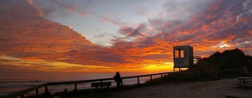
Undeveloped ocean beaches like Venus Bay typically have a different shape in summer and winter. Normally in Australia these are called the Summer Berm and Winter Berm. At the moment you can see both shapes and we haven't seen a true wide summer berm develop along the beach for several years (possibly 2006/2007 was the last period).

So What is a Summer Berm?
The term Berm has a few different meanings, It can be a mound of earth set up to protect low lying areas behind it (a levy bank). It the USA it often is the name given to a beach or flat river bank or even the edge of road. Any sub level surface will be called a berm but the flat/horizontal part will be called a Bench , the change of slope called the Berm Crest and the sloping front face the Berm Slope.

During summer when the waves and swells are generally calmer the top part of the beach start to dry out and wind action starts to level out the beach changing its gradient and making it flatter. A surprising lot of sand can be moved bu the wind and often extra sand is "stolen" from lower wetter parts of the beach and builts up this top part of the beach. The first sign most of us will notice is a soft sand pile built up at the bottom of the ramp or steps down to the beach.

In winter, storms and pounding winter swells bringing a lot more wave energy to lift and redistribute the sand both on the beach and below the waterline. The shape is now a single gentle curve getting steeper up the beach. Whilst the winds can be stronger in these times the sand is generally very wet so less wind erosion in involved. The winter shape has dominated changes in the Venus Bay beach over the past few years.

I am beginning to suspect the return of the sumer berm is related to the general change to a northwards longshore drift.

It will be interesting to see if the hooded plovers and other shore birds have a more succesful breeding season with a wider upper beach and less risk of nests being washed away.

Tuesday, January 11, 2011

Pipi shell survey

The Pipis of Venus Bay are back making news in the local papers. The community has concerns regarding the impacts caused by people collecting Pipi on the surf beaches of Venus Bay. While the political debates are discussed elsewhere, the food web continues down on the beach. In our time of randomly sampling empty Pipi shells for signs of how/why they died we seldom see many examples of predation by predatory snails. The Naticidae leave a distinctive drill-hole mark on their victims, below top is a close-up of the hole a Naticid made in a Surf Clam shell. Nicely bevelled work!


In the shell survey I did on the beach Northwest of Beach Five on the 9Th Jan 2011 the chipped/non-chipped ratio was 9/10 in favour of chipped shells below bottom. The one exception was a Pipi shell with a Naticid hole.
We do this survey to gain information over time on the causal factors of Pipi mortality, but it also gives us some idea of the sizes of the Pipis present and how the Natacids (& others) are faring.
Does anyone know if Oystercatchers leave tell-tale marks on shells when they predate them?

Testing the sand drift

On the summer by the sea walk we tried a simple experiment. By quickly digging a trench in front of a wave, then we watched carefully as the backwash from the wave refilled the trench.

Thanks to steve for the video
image If you watch, you will see the first and main backwash is from the top right (south eastern side), but then material also washes in from the top left (north western side). So the waves are not washing back down the beach in a uniform direction and maybe even our trench is influencing the backwash a little. Still we repeated the test three times with much the same result. So we must assume an inconclusive result that the sand is mostly washing to the north west (ie coming from the south east) which is consistent with the form of the sand bars, which joins to the beach at the southern end in this location.

Geology (and MORE) walk at Pt Smythe

This photo above was taken looking NW towards Pt Smythe during the Summer by the Sea geology walk at Venus Bay. The weather was kind to us as Norm Hanson led the tour through the diverse habitats introducing us to the plants, animals, geological theories and history of Point Smythe.

Warragul spinach.
The creeper scrambling here in this photo left was a food plant for the indigenous peoples of the area. The Kulin people used this and many other food sources during their seasonal passage through their traditional lands.


I was hoping to post a video of Norms longshore drift experiment on this site, but I have had trouble. Id like to blame the Sand Fly bites I got, but thats not deserved. I have managed to get some video on my Flikr, so here are a couple of links;


Monday, January 10, 2011

Where are all these crabs from?

Sand Crab [Ovalipes australiensis]
I'm sure you’ve notice either the large number of crab shells and carcasses on the beach this summer or more likely you've felt something nipping at your bare feet in the shallow surf. The culprit is the Sand Crab [Ovalipes australiensis]. They are common enough and a favorite food for the pacific gulls. But why so many this year?

Please leave a comment is you think you know why.


A word of warning for the keen surf fisherman from the Museum Victoria, Ovalipes are experts at removing bait from fishhooks!

Sunday, January 9, 2011

A good day for a walk

I hope those that braved the walk out around Point Symthe area had a great day. One of the highlights was seeing a pair of hooded plovers possibly at a new nesting site and some oyster catchers resting on the beach.

Hooded ploversOyster Catchers

The experiments with trying to directly observe sand drift, where not totally conclusive (steve may have photos) but overall seemed to show more movement to the north west than south east. This corresponds with the direction obtained by reading the sand bars, which where attached to the beach at the south eastern end.

pano-2

Tuesday, January 4, 2011

Photographing the sunset

This time of year the sunsets at Venus Bay can be specular, plus we probably also have the time to sit and watch them. The beach at Venus Bay is actually oriented mainly north south and faces west so you can watch the sunset into the sea. You will be able to photography sunsets over the water equally as rich and warm as those from the famed cable beach in Western Australia (ok we don’t have camels)

Pointing your camera (especially automatic digital ones) straight at the sun however often leads to disappointing results. The main problem is the exposure (the light meter in cameras often get strong contrasty subjects wrong) and photos are bleached out or have a flared out overexposed fussy light burnt into a dark image). One trick is to half press the shutter button pointing while away from the sun (this will get the light meter to correctly read the average lighting) then keeping your finger on the button move back to looking directly at the sun and finally pushed you finger fully down. It may take a little practice but with a digital camera you can view what you just took. Another alternative is to use bracketting (I pretty well always do this now for sunsets). This is a feature on most digital cameras now that will take 3 or 5 pictures at once with different exposures. But there is plenty of other good advice on the net,such as digital photography school and wikiHOW. Sunsets make great personal screen savers/wallpaper on your computer

If you look at my photography blog you will see sunsets are a favourite subject. Here are a few sunsets already in the VBOP group on flickr, perhaps you would like to add more. Lets make Venus Bay as famous for sunsets as cable beach.

Into the sunset the setting sun vb beach sunset panorama

Alas the beach one surf life saving observation box is no longer

Monday, January 3, 2011

Surf Diatoms on Beach Four

A small Diatom bloom on Beach Four today (3/1/11) .
Beach Four has signs of undercutting of the foredune. The access path is very steep due to slumping of the dune it passes.
I noted one dead Little Penguin lying on the dunes.
We surveyed the Pipi shells on the beach for a chipped ratio of 10 out of 11 shells. The smallest shell being from a sexually immature juvenile individual approximately 8-9 months old.