Tuesday, December 28, 2010

Reading the sandbars

Most of the action on the beach at the moment is occurring down at the low tide line. If you look there is extensive development and changes in the sand bars. You can read the direction of the longshore drift of the sand by analysing the sand bars.

Look to find which end the bar is connected to the beach. If this is at the southern end of the sand bar the net longshore sand drift will be going to the north. If connected at the northern end the net longshore sand drift will the going south.sand drift

Note: Diagrammatic only & not to scale

The mechanism of longshore drift on a long sweeping beach like Venus Bay is fairly easy to explain. The wave hit the beach slightly obliquely (this depends of ocean currents and nearby coast and sea floor topography) and carry some sand particles up the beach in the same direction that the wave was travelling as it hit the shore. Then the wave receded but now the water runs down the gradient of the beach (ie at right angles to the beach) so some sand is again washed back but following this new flow direction. so the sand particles zig zag up and then down the beach moving them along the shore a little as each wave carries them up the beach.

Very much related to the development of sand bars along the Venus Bay beach are Rip currents. These are feed with water but the lagoons and depressions that form behind the sand bars water coming over the bars has to run along this hollow to get back out to sea. Sometimes it quickly erodes deep gutters (a favourite pace for surf fisherman at higher tides) or pot holes. Often the sand near the deeper pots holes is very loose and unconsolidated because it is recently transported there.

Over the past few years the longshore drift has been dominantly to the south but this year It would appear that the general sand drift has turned to the north. It would be nice if all those interested observed the sandbars and posted their observations of sand drift  as comments here or as messages  on Twitter using the either hashtag #VBOP or to @VBOP

Eg for twitter

@VBOP beach one sand bars show sand drift to north

Friday, December 24, 2010

Beach One Christmas Day

Beach One Venus Bay


Christmas sunrise at Beach One, Venus Bay. As imageo mentioned in his last blog, the low air pressure and Lunar influence combined might lead to further sand movements and erosion along Venus Bay's coastline. The picture left has mounds of sand running parallel to the shore, and right shows how uneven the erosion to the berm is, as it persists in these deeper troughs. The fore-dune has experienced some erosion in places too.
Behind it the primary dune is suffering blow outs, often caused by people walking up and over the dune system, then enlarged by prevailing winds. We would remind people that besides being important habitat, the dune vegetation plays a critical role in stabilising the dunes, ie the beach. Besides that have a happy and safe Christmas, enjoy the beach and drive carefully.

Sunday, December 19, 2010

Lunar Eclipse @ Sunset Tuesday 21st.!

For those interested, and clouds permitting, you will be able to a partial eclipse of the moon should be visible just before sunset as the "full" moon rises (approx 8:40pm) and best time to view will be as the sunsets, with the moon still low on the horizon and appearing larger than usual. The partial eclipse will reach it midpoint around 9:15PM and be complete by 10pm It should have a reddish colouration over much of the moons surface (not as complete as shown in photo from the June 2009 lunar eclipse but distinctly reddish all the same).

The best places to view the eclipse at Venus Bay will those places with a good view of the eastern horizon, such as the overflow Carpark on the way to beach one, OR on the Venus Bay/Lower Tarwin bike track at the beginning of Jupiter drive OR at the boat ramp at Estate 2.

Wikipedia has more details on this eclipse. This Blog has details of best viewing time for some Australian cities.

The 21st also marks the summer solstice (the shortest night of the years), The full moon and the tails of low air pressure and cold front (bringing the cold and cloudy weather) may bring higher than average tides and a slight possibility of more erosion and sand movement at the top of the beach. All in all a good night to get out and take a look at what is going on, albeit with a raincoast and umberella.

Thursday, December 2, 2010

Beach One berm watch


This is the state of the berm at Beach One on 2nd December. View is towards Southeast during the low tide, at 11 AM.
Note the lower inter-tidal zone with sandbars and sitting water.

Monday, November 22, 2010

Beach Five update


Visited beach 5 today and took these photos of the fore-dune. To the West the dune looks alot more stable compared to the view East where the active undercutting is visible. The seaward half of the inter-tidal zone is fluffy with the transported sand. I also counted 6 dead Shearwaters. Also found my 1st Pipi from here with a Natacadea borehole. Usually these predatory snails are out competed by more efficient hunters.

Wednesday, November 17, 2010

What is a Spit?

The geomorhpic definition of Spit is a sandy bar projecting from the mainland into open water. Spits are formed by deposition of sediments moved by longshore drift. (here is a wikipedia link on spits, if you want more details)


So the Big question; Is Point Symthe a Spit?

Well it is widely described as a spit in tourist literature guide books, Often as Victroia's largest spit. However there may be a few problems calling it a true spit
1) The Andersen inlet estuary is no longer "open water" and there is a very strong tidal inflow and outflow cutting across the longshore drift
2) Observations in this project suggest that the longshore drift does change directions and has been larger going southwards for the past few years
3) It doesn't have the characteristic hooked end.

Yet physically it is a very large continuous section of sand and the present situation may represent a very late stage of spit development. Where by the entrance to Andersen inlet may close over with a continous sand bar from Point Symthe to Inverloch.

However as Andersen inlet gradually fills with sediment (not sure if anyone is accurately measuring this) The effects of the tidal flows (it is the same amount of tidal change but in a progressively shallower inlet) mean that there is now considerable erosion cause along the main chanels giving outlet to the sea. These infact are behaving like a meandering streams thrashing back and forth across the inlet floor and heavily eroding the coast & beaches but just at very specific locations (where the chanels curve most).

Who will win? Longshore drift or the tidal flow from Andersen Inlet.

Thursday, October 28, 2010

migration mishap

IMGP6481-1
IMGP6479Now is the time of migration for many of the birds that nest along out coast. The shearwater [Puffinus tenuirostris] (more common knownly as the mutton birds) flies in from as far north as the Siberia, the Aleutian Islands and even the Californian coast. Unfortunately this year something happened and the beaches at Venus Bay are littered by hundreds of dead bird. Stormy weather probably isn’t to blame as most bird appear to have only recently died, a period of mild weather and calm seas and light sea fog. Presumably they died of exhaustion from their trip unable to summon the strength to continue to their nesting sites.

IMGP6480In 1798, Mathew Flinders recorded watching an almost continuous line for several hours of shearwater leaving the waters of northern Tasmanian and heading across bass straight on the start of their migration north.  He estimated that there were at least one hundred million birds within a single flock!

Sunday, October 17, 2010

Beach-Nesting Birds Workshop & Beach Walk

Learn about Birds Australia’s Beach-nesting Birds project and how to safely monitor nesting
birds. All welcome!

Location: Venus Bay Surf Life Saving Club (Surf Drive)

Date: Saturday 6th November
Indoor presentation: 11:00 am -12:00 pm
Break for lunch 12:00 - 1:00pm
[Bring along your lunch; tea/coffee/juice and cake will be provided]

Beach walk*: 1:00pm departing Number one beach (end of Surf Drive), heading east along the beach. We will walk at least 1km and depending on your fitness, there is the option join us on a longer walk.


* For those going on the beach walk, please be prepared for the weather and bring along wet weather gear or sun protection as required. If you have binoculars, please bring these along. You might want to bring along a bottle of water to keep hydrated.

Friday, October 1, 2010

More on Size Matters

There is a large aboriginal midden south of beach one on the edge of a large sand blow out. Recently a lot of the of the midden have been eroded out and formed a long scree field mainly of pipi shells below the midden. Look over the shells it was soon evident that the average size of those shells collected and eat my the aboriginals 200+ years ago is significantly bigger that even the largest shell I could find on the beach today.

Thursday, September 2, 2010

Plenty of Diatom Blooms

IMGP5436 There are a number of patches (5-15meters wide) where ever I looked along the Venus Bay beach today. Whilst the foam and waves where heavily stained, the amount of staining on the beach at low tide (early morning) is consistent with the “urban legend” that these blooms are only a day light phenomena. The characteristic circular patterns as the diatoms slide off bubbles in the surf foam are still the easiest way to identify these surf diatom blooms.
IMGP5399
Surf Diatom Bloom at Beach 1
IMGP5461
Seperate bloom of Surf Diatom At Beach 5

What scum is that?

IMGP5368
The recent heavy rains have all the low lying areas and drain permanently full of water, and a lot of different slimes, algaes and mosses growing rampantly (mainly in bright shades of green). Whilst most are not harmful it is important to realise that the relative shallow depth or Andersen inlet makes it a high risk for damaging algal blooms, such as the toxic blue-green algae. Some blooms such as diatoms (more likely to be a greeny brown) can be benefical.  The NSW office of water, give details of how to obtain a copy of “What scum is that?” an aid to identify Algal blooms and other prolific plant growths and a simplified field guide called Keys to blooms.

Tuesday, August 24, 2010

Mars close encounter internet myth or ...

There are a lot of stories circulating on the internet about a close encounter with mars on the 27th August. Well they are not true, the earth does come close to the orbit of mars on 30th October (if 69 million kilometers is considered close) and it will be visiable to the naked eye, but it already is. The really bright start after sunset at the moment in the western sky is venus and mars is the dimmer reddish star above it. The bright star close to the full moon is jupiter.

Find out more about this "real" photo at the NASA mars-mythbuster site

The planets Mars, Venus & Jupiter can have a slight affect on tides. However the largest effect would have been at the last new moon when all three, the sun and moon where in close alignment and the effect was apparently minimal!

Tuesday, August 17, 2010

Second chance for 75 Litres of Venus Bay Pipi

The current edition of The South Gippsland Sentinel-Times, Tuesday August 17 2010 page15, is carring a story on Pipi poachers intercepted by Fisheries officers at Venus Bay. The five alleged poachers were apparently caught with 75 litres of Pipi. That is 60 litres over the legal catch limit.
The best news of all is most of the Pipis were returned back into the surf.
Anyone who sees or suspects illeagal fishing activity should call 13 FISH (13 3474).

Tuesday, August 10, 2010

Another light show in the sky

On the morning of the 13th August there will be an aligment of Venus Saturn and Mars, and a crescent moon in the eastern sky. Unfortunately it will occur a little after sun rises and not break on the eastern horizon till almost 8am. What you might see with the naked eye is a thin cresent moon and a bright star (venus) nearby The famous Perseid meteor shower should then becoming to its maximum at roughly the same time on the northern horizon, or slightly east of north. A great place to view this is from the bike track to Lower Tarwin on the rise at the start of the track near the intersection of Jupiter boulevard and Lees Road.

View Viewing perseids meteor shower in a larger map
Look across the adjacent field at the horizon to the right of the Pine trees close to Lees road, just before dawn, for the best chance of viewing meteor trails.

The moon, sun and planetary alignment in conjunction with the current lower air pressure (stormy weather) is likely to produce a very high tide and lead to significant new erosion at the top of the ocean beach profile.

There is a great article on viewing the alignment & meteor shower by Dr Tony Philips of Nasa, but remember his times and date relate to the Northern Hemisphere.

Thursday, August 5, 2010

Lightshow over (for now)

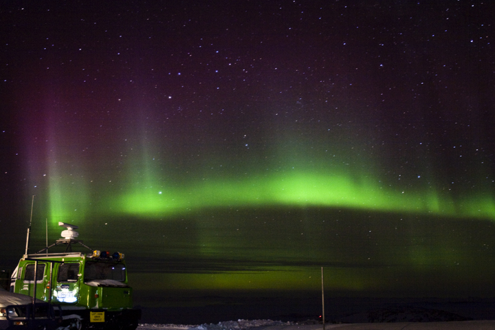
"We missed the major part of the storm--wrong side of the planet--but still caught some bright Southern Lights after the sun went down," Tom Luttrell photo from Australia's Casey Station on the coast of Antarctica (source spaceweather.com)

So the current magnetc storm may be over but there may be many more opportunities to view the southernlights from Venus Bay as the 24 year sunspot cycle climbs towards its expected maximum in 2013. This VBOP site will endeavor to keep you posted when good sightings are likely.

Wednesday, August 4, 2010

Keep an eye on the sky at night


Two large solar flares occurred on the sun on August 1st.(source spaceweather.com) The first of the resulting magnetic storm arrived at the earth yesterday and triggered spectacular north lights. It is possible that a similar light show may occur in the southern hemisphere tonight, and more storms are expected. So when the sky clear, keep an eye out for auroras in the southern sky

Did you know Australia actually has a space weather bureau? Well is it actually a geopyhsical conditions monitoring authourity, but it does offer an aurora alert on its website. Nothing is confirmed as yet. However tonight and the next few days are definitely the time to monitor the southern sky.

PS If your mobile phone is registered for the alert system, expect an SMS if & when the aurora is visiable.

Sunday, July 25, 2010

Beach Five Friday 23rd June 2010


Diatom bloom in surf. Changes to berm on-going.
Water temp: 13.7c Air pressure: 1031 hpa.
Air temp: 12.6c Chipped Pipi shell ratio: 9/10.
Beach Five continues to move towards a flatter beach profile with erosion and transporting of sand from the upper to the lower foreshore.
Tracks used by the Pipi over-harvesters show fresh footprints. Apart from filling a few pot holes in the carpark, no other maintainance or works has been done by Parks.

Sunday, July 11, 2010

Beach Report, Beach Five.


Carapace of the Surf Crab ovalipes australiensis, we noted about five washed up onto the beach. Probably victims of the storm conditions over the last few days.
We also saw multitudes of cuttlefish 'bones' washed up.
No blooms were seen.
Air pressure; 1013 hpa
Air temp; 16.3c Water temp; 13c.


Two Berms

Are there two berms on Beach Five? The berm near the foredune ( & the sign) is the berm that was here on my last visit, although it has worked itself higher up the beach.
But a second mini-berm is also apparent, extending from the bottom right of photo.

DUNE REPORT, BEACH FIVE.


The white varity of the Pink Wax-Flower eriostemon austrasius is begining to bloom. Is this early, the books say it is a springtime flowerer?
Other news from the dunes of Beach Five, Pipi hunters have cut part of a wire fence so they have easier access into the dunes for their clandestine enterprises.

Friday, July 9, 2010

The Wedgie

image
A sole wedge-tailed eagle [Aquila audax] was circling high above the dunes between beach one & beach two for approximately 20 minutes. Then suddenly it was gone.
image image image
image image image
The wedge tail is darker and has a longer wedge shaped tail than the white-bellied sea-eagle [Haliaeetus leucogaster] which also can be seen occasional over Venus Bay.

Wednesday, July 7, 2010

Small Blooms in the Surf

There were two small blooms of  surf diatom between beach one and beach two today. It was definitely cold with and on-shore wind.

Saturday, July 3, 2010

Those brown sludges

Those brown sludges that re-occur from time to time (more often in the cooler months april to july) along the clean sand beach at Venus Bay are normally due to "blooms" of surf diatoms, and they are not due to pollution. These diatoms are not toxic, although they may cause some skin irritation. So it is advisable to avoid swimming in dense patches or at least shower after swimming or surfing.


These diatoms are small marine plants that have a silica casing (and are therefore heavier than water). The diatoms mainly live in the sand but use the foam in the surf zone as a means to stay afloat and spread. As the foam washes ashore, the diatoms slide off and/or the bubbles of foam burst leaving a characteristic ring pattern in the sand. Large accumulations of diatoms are naturally occurring and the diatom themselves are a major food source for prawns, fish and filter-feeding molluscs (such as pipis).

The EPA (see link below) suggest these "Blooms" of surf diatoms may be related to weather conditions, particularly onshore winds. Similar blooms on the pacific coast of USA are linked to upwelling in cold water currents (the suggestion is that the change of temperature precipates iron from the sea water and feeds the bloom).

So a nice side observation project for us is to record when the blooms are visible and how extensive they are, also the wind conditions and temperature (hot, warm, cool, cold, very cold is probably sufficient for now, but there is a link to the Pound Creek weather station over on the right-hand column of this blog). The most important observation is to distinguish them from other sludge/pollutants such as oil spills, untreated sewerage or other effluents.
  • They have a distinct golden coffee colour
  • They do not smell (of oil fumes or in fact any distinct smell)
  • No iridescent (rainbow-coloured) slick on the water surface
  • They are not sticky and if you collect them just on the stained surf foam it feels gritty
  • They do not form blobs or lumps in the sand
Much of this information comes from the EPA's Surf Diatom Page

Thursday, June 24, 2010

0n the Frontline

SMS 041 730 6986


Frontline.SMS is an open source award winning application by Kiwanja.net. It is a simple to use "not requiring the internet" way to interact with the others in the project, that will allow any of us to use simple SMS text messaging from a mobile phone to submit observations and recieve news and warnings. All at a minimal cost.

You can Submit an Observation to be recorded in our database and posted on the website by starting your message with the Keyword VBOP. This means you will be able to send in things as you see them on the beach or wherever you are. It will just work of text messages, not photos.

You can also join a special Warning and Alert Group. Just send JOIN to the SMS Number (041 730 6986). Those Joining up will only recieve occasional messages related to specific VBOP alerts such as expected king tides, possible flooding or important beach news (such as the toxic chemical drums being washed ashore)
You can also choose to leave the group and stop warnings by sending LEAVE to the SMS number(041 730 6986).
Finally the small print. Please note the service is not online continuously but will be cleared daily. There is no charge for these messages, other than the normal SMS charges imposed by your telephone carrier (eg Telstra or Optus) 

Wednesday, June 23, 2010

NEW LOW IN SIZE OF HUNTED PIPI

22/06/2010
The size of a Pipi hunters midden at the rear of Beach 5s carpark beggers belief. How much longer can the population survive when this is the size that they are down to taking out?
These little guys ( 5 cent peice for scale) never got a chance to breed and set the next generation.
The Pipi hunters are also wearing a track through the dunes off of the proper access track, obviously not what people who are taking a legal catch size would do. Besides the Pipi carnage, this impacts the beach in multiple ways. From the blowout of the dunes to the disposable nappies littering the sides of the tracks, if Venus Bay is your beach then this is whats happening.

Thursday, June 17, 2010

Being open

I'm putting a bit of work into ways that this VBOP project can use other common web social networking tools and sites to broaden itself. More particularly to make our information easy to submit and use. Well I guess it is not secret but the systems have to be OPEN not closed! Sound simple but it is hard to explain why in a short post, but that is not important.

There is already a presence in Flickr and Twitter. Expect to see some news on BUZZ,  A Picassa Web Album, a wiki style Field Guide and even a neat mobile phone data collection application using Fronteline.SMS

But don't expect to see any Facebook follow me or friends requests or even Like buttons here anytime soon.

Wednesday, June 16, 2010

Venus & the Crescent Moon

Venus is visible as a very bright start at and just after sunset in the west and yesterday it was very close to the crescent moon.

A great photo opputunity!

By the way Venus Bay is not named after the planet Venus. It was changed to Venus Bay by Francis Peron on one of Baudain's Charts, and is thought to have been named after George Bass's ship the copper sheathed brig Venus. In appreciations of Bass's kindness in providing the distressed French expedition with fresh food.

Monday, June 14, 2010

Why are Moon Phases Important?

I've included a phases in the moon applet over on the right because the position of the moon, more particularly the alignment of the sun, moon &earth, has a big influence of the magnitude of our tides. We see these tides as a roughly twice daily rise & fall of the sea level. The so called spring tides, are not just limited to spring (or autumn), they occur roughly twice a month (as the graphic above shows) at either the new moon or the full moon. Other times of the month see lesser tidal range because the gravitational pulls are not aligned. You can get the predicted tide times from the Bureau of Meterology Website (Venus Bay tides are roughly the same time as for the Port Phillip Heads)

Venus Bay does get higher tides in spring and autumn that have a significant extra height due to strong ocean swells and waves. Sometimes these highs can be forced higher by a storm surge or strong on-shore winds.

So the new moon this weekend make it a candidate to see more erosion, possibly higher than last month.

Wednesday, June 9, 2010

Please Be Patient

I have begun transferring post from the old free NING site (which will be closed done at the end of the month, Not Happy NING!) to here. Where possible I want to have the same information and photos available here. However getting the photos across is very manual at the moment so I will be doing a few posts at a time.

Unless someone knows a magic way to automate this transfer?

Monday, June 7, 2010

What is the Creative Common Licence About?

Creative Commons License
This work is licensed under a Creative Commons Attribution-Noncommercial-Share Alike 3.0 Australia License.

You may be puzzled, why I have put a Creative Common Licence on this blog? This is a public viewable blog, so it is necessary to make it clear that the information and photos we are sharing here do still belong to the person sharing them and that they may be used and reproduced elsewhere only under a set of specific condition. If your works are used then the must include an attribution to yourself, and please note anyone reproducing things from here it is common courtesy to notify the person who posted or submitted a photo. They can not be used for commercial purposes and they must be shared in the same form (ie under the same CC licence). In other words if someone wants to use or copy your work claim "Fair Use" because it is published under in the "Public Domain" (ie on the internet) then that fair use does have specific limits! This is to protect those wanting to share their observation and work.

Even if you share a post or link to a photo from here, you are entitled to have a more limited CC licence for your work. For example Flickr supports CC licences and encourage their members to set them by default for your photostream but also lets you individual set licence and access to photos individually. Posting or linking from here does not override that licence.

Sunday, June 6, 2010

Welcome

This is a new home for The VBOP project. It was formerly set up as a free NING group but unfortunately that will be closed down at the end of this month. So all the connect from there will be moved over to here (well most of it, everything t6hat is possible).

Also this site will be set up a little more opening than before, you don't have to join anything, you can post your observations elsewhere in the many Social Networks that make up WEB 2.0. This [place should be a convenient place for you to link to those places, post & photos.

This will also be a great place to find out what needs to be observed and how to record it

Wednesday, March 17, 2010

Drifting North Again

This panorama was taken at the beach 5 car park and shows how the sandbars are attached to the beach at the southern end (see this photo full size). You can also see the ruts developing into rip channels also point to a return to genrally northerly longshore drify

Wednesday, February 10, 2010

Does Size Matter

Pipi Shell from Venus Bay (note the chipped edge again)

Compared with Pipi shells in New Zealand.
My hand is the same one in both photos, by the way. I suspect the shells are the same species. The difference is there is a "cultural" size limit as well as a 150 bag limit when collecting Pipis, and most shellfish, in New Zealand.
Do we need a size limit as well as an enforce limit to be imposed? Before all the pipis are gone from our beach.

Tuesday, January 12, 2010

I undertook an improptu survey of pipi shells as I walk from beach 1 to beach 2. I picked up the larger shells thinking i would check their size. then I noticed their edges. Of the eleven shells I had picked up, ten had chipped edges. Further none had the tell tale little hole near the crown indicating they had been killed by another hungry mollusc. These shells where probably all forcefully open with a knife! To say the least I was shocked that they vast majority of shells showed sign of being open and discarded on the beach.